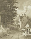
 The village of Partick lay north of the River Clyde, west of the River Kelvin and south of the Highway. For some time the western boundary was near where Anderson Street is today, not moving further west until the mid-1800s. The village did not extend north of the Highway until after the 1797 bridge was built. The main road through the village began at the northern end of the old Partick Bridge which had a toll on it. Called the Meadow Road, it led to the meadow on the western outskirts of the village in the area now called Meadowside.
 From the 1500s further development occurred when five additional mills were built on this stretch of the River Kelvin. There were at least five inns, catering for villagers, travellers and visitors from Glasgow. Glasgow merchants enjoyed duck dinners – the ducks having been feeding on the grain from the mills. During this period Partick was considered to be out in the country.
 Apart from milling, the main occupation was weaving – initially on handlooms until the Lancefield Spinning Factory was built. Besides printworks and bleaching works, there were also coal and quarry workings, while several farms existed around Partick.
 There being no church buildings, Established Church worshippers had to travel to the parish church in Govan. Others had to travel to Anderston or to Glasgow. Houses had thatched roofs. There was no lighting on streets, open ditches and burns were used as sewers, and middens and piggeries caused stagnant water to gather unhygienically.