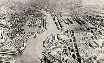
An aerial view of Glasgow Harbour probably taken in October 1932.
The horse-shoe shaped Queen's Dock is clearly visible centre left. Opposite, on the south bank of the River Clyde, is Prince's Dock. During the 1890s Govan Road was re-aligned to run along the boundaries of the new Prince's Dock. It continues west parallel to the river, past the Clyde Navigation Trust's three graving docks (two of which are occupied by ships undergoing repairs) and Harland & Wolff's shipyard.
The mouth of the River Kelvin can be seen in the left hand corner of the image. Yorkhill Quay lies between the river mouth and Queen's Dock.
Reference: 143.80.25
Reproduced with the permission of Glasgow City Council, Glasgow Museums
Keywords:
aerial views, Clyde Navigation Trust, dry docks, fitting-out basins, Glasgow Harbour, Govan Graving Docks, Harland & Wolff, Prince's Dock, quays, Queen's Dock, River Clyde, River Kelvin, shipbuilders, ships, shipyards, Yorkhill Quay
You have 0 images in your photo album.