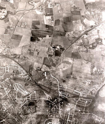
An aerial photograph of Possil Loch (the dark outline in the centre) and surrounding areas taken in March 1950 by the RAF.
Balmore Road runs from north to south down the middle of this photograph. The Forth and Clyde Canal crosses diagonally from top right, at Bishopbriggs Golf Course, to the junction at Ruchill where one branch leads west to Bowling and the other south-east to Port Dundas.
To the right of the loch lies farmland on which the council housing estates of High Possil and Milton were built in the 1950s, and the vast Lambhill Cemetery (1881) and Western Necropolis (1882) along with the small St Kentigern's Cemetery are on the left. Near the bottom, centre, the well-ordered rows of Ruchill Hospital's pavilions are clearly outlined next to Ruchill Park.
In 1956 Possil Loch and the associated wetlands were designated as a bird sanctuary, and in 1982 the Possil Marsh Reserve was gifted to the Scottish Wildlife Trust. Over 100 species of bird have been sighted in the reserve, as well as roe deer, dragonflies, butterflies and amphibians.
Reference: 1101
Crown copyright is reproduced with the permission of the Controller of Her Majesty's Stationery Office
Keywords:
aerial views, bird sanctuaries, birds, Bishopbriggs Golf Course, canals, cemeteries, fever hospitals, fields, Forth and Clyde Canal, golf courses, Lambhill Cemetery, lochs, marshes, parks, Possil Loch, Possil Marsh Reserve, RAF, River Kelvin, Royal Air Force, Ruchill Hospital, Ruchill Park, Scottish Wildlife Trust, St Kentigern's Cemetery, Western Necropolis, wetlands
You have 0 images in your photo album.