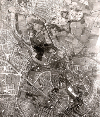
An aerial photograph of Maryhill, Anniesland and surrounding areas taken in March 1950 by the RAF.
The Great Western Road cuts across the bottom left corner of this image, with the busy Anniesland Cross road junction just left of centre. Below the junction lie Broomhill and Jordanhill, with the extensive grounds of Gartnavel General and Gartnavel Royal Hospitals. The gasometers at Dawsholm stand out clearly to the north-east of the cross and to the east of them are Kelvindale, Kelvinside and Wyndford, all lying to the south of the Forth and Clyde Canal.
The dark area in the centre of the image just north of the canal is Dawsholm Park and the other lands of the old Garscube estate, bordered on the left by the Switchback Road and on the right by Maryhill Road. To the east of Maryhill Road lies the farmland on which the Summerston housing estate was built in the early 1970s. The River Kelvin can be seen running down from the top right corner through Killermont in Bearsden and on through Maryhill, Kelvindale and Wyndford to Queen Margaret Drive in the bottom right corner.
Reference: 1207
Crown copyright is reproduced with the permission of the Controller of Her Majesty's Stationery Office
Keywords:
aerial views, canals, Dawsholm Gasworks, Dawsholm Park, Forth and Clyde Canal, Garscube Estate, Gartnavel General Hospital, Gartnavel Royal Hospital, gasometers, gasworks, hospitals, housing estates, housing schemes, parks, RAF, River Kelvin, Royal Air Force
You have 0 images in your photo album.