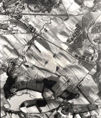
An aerial photograph taken in January 1959 by the RAF, showing the Darnley and Deaconsbank areas .
All the contours of the snowy landscape can be seen in this beautiful image. Waulkmill Glen Reservoir lies in the bottom left hand corner with the dark outline of the woods of Waulkmill Glen to the north. The Brock Burn winds emerges from the glen and winds through the fields to the north on which the Darnley and Deaconsbank housing estates were subsequently built. Nitshill Road cuts diagonally across the top of the photograph, from Nitshill on the left to Arden at the junction with Stewarton Road on the right.
Nitshill (with neighbouring Hurlet) came within the city boundaries in 1926 and the Darnley area was added in 1938.
Reference: 237
Crown copyright is reproduced with the permission of the Controller of Her Majesty's Stationery Office
Keywords:
aerial views, Brock Burn, burns, council housing, fields, housing estates, housing schemes, RAF, reservoirs, roads, Royal Air Force, snow, streams, Waulkmill Glen Reservoir
You have 0 images in your photo album.