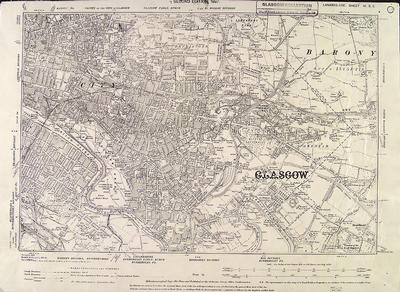
The second 6 inches to the mile Ordnance Survey map of Glasgow was published in 1896-1897, being a revision of the 1858 survey. This is the south-eastern section of the city, Lanarkshire Sheet VI SE. The area covered by this sheet is 6 miles east to west and four miles north to south. Contour lines are shown.
The dotted line is described as the county boundary, Glasgow having been raised to the status of County of the City of Glasgow in 1893. The River Clyde forms part of the boundary, a natural division between Glasgow and Rutherglen.
The old city centre area is shown in this section, including such well known landmarks as George Square, Glasgow Cathedral and Glasgow Green. "Her Majesty's Prison", to the south of the Cathedral, is Duke Street Prison which closed in 1955. Further east, the Parkhead Forge & Steel Works of William Beardmore & Co stands out, with Celtic Park to the south of it.
Reference: Mitchell Library, Glasgow map drawers
Reproduced with the permission of Glasgow City Council, Libraries Information and Learning
Keywords:
Celtic Park, city boundary, contours, Duke Street Prison, George Square, Glasgow Cathedral, Glasgow Green, maps, Ordnance Survey, Parkhead Forge, prisons, River Clyde, William Beardmore & Co
You have 0 images in your photo album.